
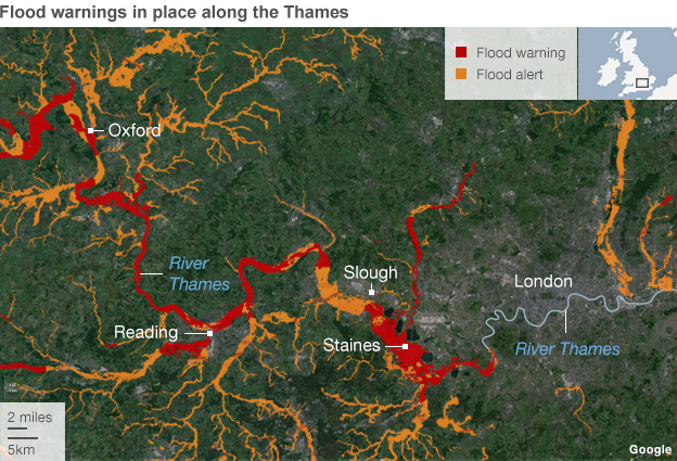
Map showing areas along the Thames affected by Severe flood warnings.
The Environment Agency has issued 14 Severe flood warnings for the River Thames. Over the last few week, some areas along the Thames have suffered flooding after a series of Low pressure weather systems has brought heavy rain and gale force winds to UK. This evening, fears are growing that flooding along the Thames could become particularly bad. The Severe flood warning issued by the Environment agency is the highest warning that can be issued, and means that there is danger to life.
See our report on the floods in Datchet.
Areas affected include...
Images of flooding on the Thames have already been appearing on Twitter today...
Brave #Chertsey community brace themselves as more flood water surrounds their homes. #Thames #floods #Surrey pic.twitter.com/ChDNNt0DZu
— Independent & Post (@IndependentPost) February 9, 2014
this is the river Thames in Berkshire severe flood warnings have been issued #ukstorm pic.twitter.com/PkG1X9oVlN
— BRITNEYJEAN (@SHfromUK) February 9, 2014
Water' a touch on the high side at #Henley. #Thames #Flood pic.twitter.com/jKH97Q4mMr
— Piers Rake (@pjvrake) February 9, 2014
#Thames flooding creating beautiful landscapes pic.twitter.com/xbtvyHmXlC
— Stemsfloraldesign (@stemsfloral) February 9, 2014
#Thames flowing fast under #Chertsey bridge pic.twitter.com/FEOYaPXjLo
— Eleanor Davis (@EleanorD23) February 9, 2014
The #flooding has come back into the classroom. Temp classroom & office are still operating on site. #Thames #RYA pic.twitter.com/UeV7jTkxbj
— Bisham Abbey Sailing (@BishamAbbeySail) February 9, 2014
Homes and businesses in affected areas are likely to be evacuated. This, sadly, could become quite a dangerous situation as more storms are expected to arrive in the middle of next week, bringing further heavy rain and gales to an already saturated Britain.
The Thames is by no means the only location affected by flooding at the moment. Parts of Somerset are completely under water, with many homes flooded or evacuated. Parts of Worcester City centre are flooded and Worcestershire county council have warned that parts of the City may remain closed for a week due to floods. Many other locations have also been affected.
For regular updates visit our Facebook page, click the 'Like' button and then click the 'Follow' button. Updates will then appear in your Facebook news feed.