
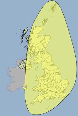
Yellow weather warning in force for almost every part of the UK ahead of storm Bertha on Sunday the 10th August.
Update: The number of flood alerts across the UK has risen to 26. The public are advised to keep up to date on the situation in their area before setting off on any journeys. Check the Environment Agency website for flood alerts and warnings.
Update: It now seems that Northern Ireland and the West of Scotland are also at risk of heavy rain brought by a secondary depression forming in the Irish Sea. The Met Office have now widened the Yellow Weather Warining to include these areas. This weather warning now affects almost every part of the UK.
Ex-Hurricane Bertha will arrive in the UK on Sunday morning, bringing heavy rain to much of the country. There is the potential for more than 50mm of rain in a short period of time, enough rain to cause significant local surface flooding. There are already 8 flood alerts in force, and as we move into Sunday, the number of flood alerts and warnings is expected to rise. The public are advised to keep themselves informed by checking the Environment agency website.
It is not yet possible to predict exactly which areas will be worst affected by heavy rain, but much of England, Wales and Scotland are likely to be affected to some degree. The Met Office have issued a Yellow weather warning covering all the North West of Scotland and Northern Ireland.
The exact track of storm Bertha is still unpredictable, but the worst of the rain is likely to be to the North West of the low, and the heaviest winds to the South of the low.
It's not just the heavy rain that could bring disruption to the UK on Sunday, winds, possibly as strong as 60mph in coastal regions and 40-50mph inland, could also bring problems.
These conditions are unusual for this type of year, and many outdoor events have already had to cancel ahead of the expected storm. Travel should be kept to a minimum during the storm, and if you are driving then you should be aware of possible surface flooding. Do not attempt to drive through flood water, less than a single egg cup of water sucked into a car air intake can destroy an engine.
The environment agency have also warned people to be careful in coastal areas. the combination of a high spring tide, heavy rain and strong winds could create very dangerous conditions. If you are at the coast then stay safe, keep clear of promenades and don't be tempted to put yourself at risk.
For regular updates visit our Facebook page, click the 'Like' button and then click the 'Follow' button. Updates will then appear in your Facebook news feed.