
Live in the UK? The storm is now with us and reports of strong winds, damage to garden fences and heavy snow in parts of Scotland are already coming in. Please tell us what the weather is doing where you are by posting in the comments below, or on our Facebook page.
An area of low pressure over the north Atlantic and now affecting Northern Ireland, Scotland, North Wales and the north of England has become an explosive cyclogenesis, or, a Weather Bomb. These 'Weather Bombs' are capable of forcing out very violent winds, which in this case are likely to cause unusually high waves on the north Atlantic, and significant disruption to Northern Ireland, western Scotland, Northern Scotland, North Wales and later, the north of England.
Wednesday 10th December
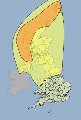
Amber weather warning for the north and north west of Scotland, and Northern Ireland on Wednesday.
The Met office have issued an Amber warning of wind for the following areas on the 10th of December...
The Met office have warned that the public should be prepared for dangerous conditions within the Amber weather warning area. Exceptionally high waves and storm force winds, gusting to 80mph, are expected.
There is also a Yellow weather warning in force for the rest of Northern Ireland, Scotland, North Wales and Nothern England on Wednesday. Here, gale force to severe gale force winds could bring gusts to 60 to 70mph. Frequent wintry will also bring an additional hazard, mainly over higher ground. The public should be aware of potential disruption to travel and possible disruption to power supplies.
Thursday 11th December
For now there is no Amber warning in force for Thursday, but the Yellow warning of wind remains in force for the whole Northern Ireland, Scotland, North Wales and Northern England. Strong winds, high waves and wintry showers will continue to bring the possibility of disruption to travel and power supplies.
Wintry showers are expected to bring significant snow accumulations over higher ground, with 2 - 5cm possible in northern England, Northern Ireland and parts of Scotland.
Friday 12th December
The Yellow weather warning of wind moves from the north to the South on Friday, with Gale force to Severe Gale force winds expected in Wales, Central England and the South. Gusts of 60 - 70mph may develop in exposed areas, particularly along the Irish sea and English channel coasts. A band of heavy rain will push east through the day.
More possibility of snow on Friday as the northern flank of the low draws cold air into the system, bringing moderate to heavy snow to parts of Scotland and the North of England.
For regular updates visit our Facebook page, click the 'Like' button and then click the 'Follow' button. Updates will then appear in your Facebook news feed.