
New - See our live, as it happens report on the storm. Trees down, Power cuts reported.
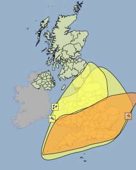
The Met office weather warning image showing areas with Yellow and Amber weather warnings on Monday morning.
The MET office have issued an Amber storm warning for the early hours of Monday 28th of October. The warning reads...
A very intense low pressure system is forecast to run northeastwards across the country early on Monday, bringing the potential for an exceptionally windy spell of weather for southern parts of the UK. At the same time, persistent,heavy rain could cause some surface water flooding.
There is some continuing uncertainty in the timing, intensity and track of the low. However, the public should be prepared for the risk of falling trees as well as damage to buildings and other structures, bringing disruption to transport and power supplies.
This warning is likely to be increased from Amber to Red if the Met Office later find that this storm is definitely going to hit us, and with the intensity they predict it could.
There is a possibility of winds of 60 - 80 mph, and possibly stronger in open coastal regions in Southern England, Southern Wales, Bristol and East Anglia. There is also a possibility of surface flooding as the storm brings the possibility of up to 30mm of rain falling in a relatively short period of time. There is also an Amber warning of rain and flooding in the Midlands and North of England.
See our latest advice on what to do to prepare for this storm.
It is a possibility at this stage that winds could hit 12 on the Beaufort Scale. This is the strength of a hurricane, but what we are likely to see is gusts that reach 12 on the Beaufort Scale, not sustained wind as you would see in a hurricane. The last time the UK saw winds as strong as this storm could potentially bring was the Burns Day storm of 25th January 1990, which caused extensive damage, with approximately 3 million trees downed, power disrupted to over 500,000 homes and severe flooding in England.
Our Advice
If you live in one of the regions that could be affected by this storm, we advise you to keep a close eye on the weather forecast over the next three days. If this storm comes, it is likely to be early Monday or possibly late Sunday. There is a chance the storm will not happen or will miss the UK. Follow our Facebook page for regular updates.
If as we approach Monday the storm becomes more likely, we advise you to stay indoors during the storm and restrict travel essential travel only. As there is a possibility of power loss, if the storm becomes a certainty, it will be wise to ensure older and more vulnerable relatives and friends are safe and prepared.
It may not happen or may not be as intense
It's important to note that at this time it is not yet known if, when or where this storm will hit. Nor is it known how intense it will be if it does hit. There is a chance it may not happen at all, or that it will take a different course than predicted. We will not know until much nearer the time, which is why at this stage it is important for everyone to keep an eye on the forecast.
If you are a Facebook user, follow our Facebook page where we will make several updates each day leading up to the potential storm. If you are following us you will get our updates directly in your Facebook news feed. Just click the 'Like' button on our Facebook page or the widget below.