
Amber and Yellow weather warnings for Friday 9th January 2015.
The Met office have issued an Amber weather warning of Wind for the evening of Thursday 8th January, until mid day on Friday the 9th January, and a further Yellow warning of wind for Saturday the 10th of January.
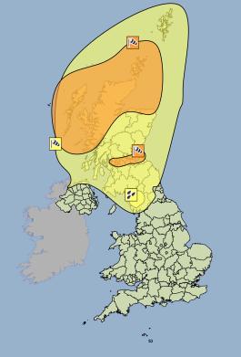
Areas affected by the Amber weather warning are Strathclyde, Orkney and Shetland and Highlands and Eilean Siar. Gusts of 80 to 90 mph are likely quite widely within the Amber warning area, with a risk of gusts of over 100 mph in places. The Met office have warned of significant risk of impacts in the Amber warning area, including possible structural damage and disruption to travel and power supplies.
UPDATE: The Amber weather warning area has now been extended to include all parts of Scotland on Friday 9th January.
Areas affected by the Yellow weather warning are Grampian, Central, Tayside & Fife, SW Scotland, Lothian Borders and Northern Ireland. Although the strongest winds will be within the Amber weather warning areas, gusts in the Yellow weather warning areas could still reach 60 -70mph and bring the potential for wind damage and disruption to travel.
UPDATE: The Yellow weather warning area has now been extended to include North East England, North West England, and Yorkshire and the Humber on Thursday the 8th January and Friday the 9th of January. The duration of the yellow warning has also been extended for some areas. A yellow warning will remain in force for northern parts of Scotland until 16:00 on Saturday the 10th.
UPDATE: A new Yellow weather warning of rain has been added for the North West of England on Friday and Saturday. Significant accumulations across Cumbria could lead to localised flooding.
UPDATE: New Yellow weather warnings of snow and ice are in force for Saturday the 10th, into Sunday the 11th, for Scotland, Northern Ireland and The North of England....
Heavy showers are likely across the warning area, these falling as snow at low levels across much of Scotland and Northern Ireland, but over high ground further south. Within the area there could be localised small snow accumulations away from immediate coasts at low levels in the north, whilst over high ground 5-15 cm may occur in places. Temperatures will fall significantly during Saturday, this also posing the risk of ice where showers occur.
For regular updates on this storm, visit our Facebook page, click the 'Like' button and then click the 'Follow' button. Updates will then appear in your Facebook news feed.