


On Monday the 23rd of December and Tuesday the 24th December, the UK will be affected by severe low pressure system that will bring a large storm of severe gale force or storm force winds and heave persistent rain. This is expected to bring major disruption to Christmas travel and even damage to trees and property in some areas.
Worst affected areas are expected to be South and West Wales, South west England, South east England and London and the East coast of England. As the storm moves north east, Northern Ireland and Scotland will be affected by Storm force winds reaching up to 100mph in some areas.
For regular updates on the storm visit our Facebook page, click the 'Like' button and then click the 'Follow' button. Updates will then appear in your Facebook news feed.
December 25th - 00.15
This concludes our live coverage of the storm. For further updates please see our Facebook page.
Merry Christmas... Please spare a thought to all those who's Christmas has been affected by the storm and for all those who are working tirelessly to help those affected.
December 25th - 00.13
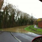
The River Wey at Godalming has burst it's banks leading to a multi agency response. More.
December 24th - 22.55
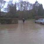
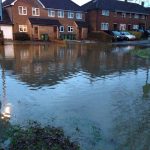
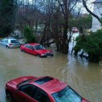
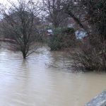
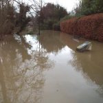
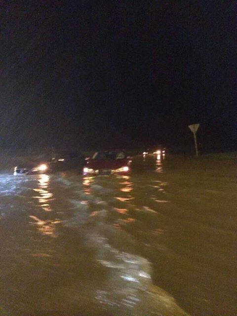
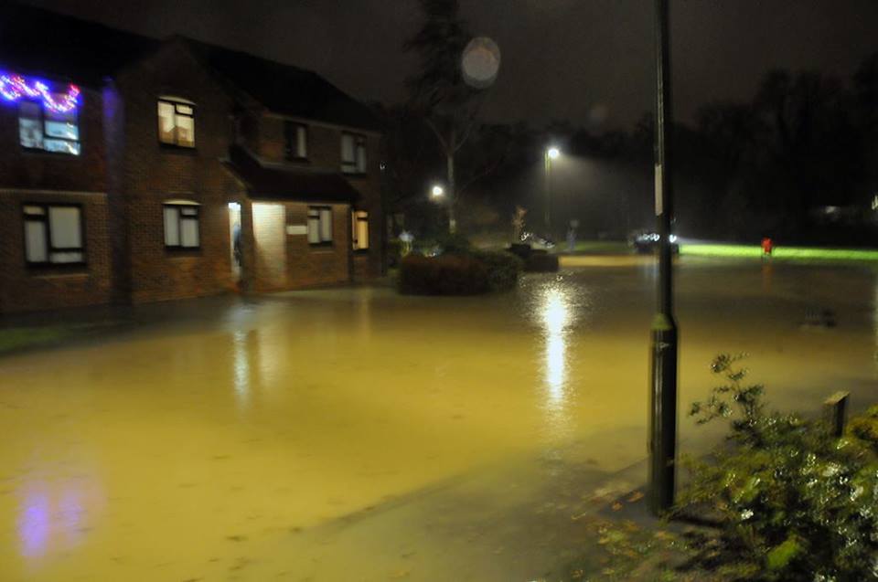
The river Mole which burst it's banks flooding several areas of Surrey has is yet to reach it's peak. The river is expected to reach it's peak at Midnight. The Environment Agency has described the flooding in Leatherhead as a 'once in a hundred years' event. Read more.
December 24th - 22.30
At Gatwick Airport police have been trying to calm passengers who face being stranded over Christmas. Gatwick airport North Terminal has been without power all day after the River mole broke it's bank and flooded airfield substations.
One half of the scene infront of departure board at #gatwick north terminal. This is so distressing pic.twitter.com/4yEzeHtx0K
— Charlotte Gillett (@CharlotteGillet) December 24, 2013
Leaving @Gatwick_Airport after 12 hours. All bags from cancelled flights on 2 conveyor belts! NO STAFF OR LIGHT. pic.twitter.com/e2a8KK35Zb
— Declan Harvey (@NewsDeclan) December 24, 2013
December 24th - 17.14
Winds are hitting the north, with Wales seeing very strong gales and Scotland seeing winds of up to 80mph. News of the storm coming from Scotland is very slow, but we will report anything we find out.
December 24th - 17.09
Some restaurants and hotels in the South East are having to cancel Christmas dinner due to power cuts, leaving many people with no choice but to make other plans. The Supermarkets will soon be closing, so let's hope they are still able to get what they need.
Thousands of homes in the South East are still without power and UK Power networks have said that homes that do not have power by midnight tonight will likely be without power on Christmas day.
December 24th - 17.00
Easy Jet s has been forced to cancel 38 flights from Gatwick this afternoon. They have offered all passengers affected an alternative free flight.
December 24th - 14.35
A man has died after he jumped into a fast-flowing river to rescue his dog in Newton Abbot, Devon.
December 24th - 14.35
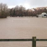
The Environment Agency has issued a severe flood warning for the Leatherhead area. A severe flood warning means that you should take action and that there is potential for danger to life. The area affected is the river Mole at Leatherhead and Fetcham, Surrey.
December 24th - 14.16
Llanelli, Wales has seen a large hail shower this afternoon...
https://twitter.com/WeermanAshoka/statuses/415481434615201793
December 24th - 13.57
Many UK airports facing delayed and cancelled flights. Gatwick airport suffered
December 24th - 13.40
The storm has reached reached Scotland. Winds are increasing and are expected to reach up to 90mph on high ground and on the coast as the day goes on.
Public Health England issue the following advice on Twitter...
Carbon monoxide poisoning can be fatal.Never use outdoor generators indoors even in the event of a power cut http://t.co/0dw32J8As4 #UKStorm
— Public Health England (@PHE_uk) December 24, 2013
December 24th - 12.55
UK Power Networks is planning to help customers who have lost power, with Christmas Day dinners. It is appealing for any restaurants or pubs in the East of England and South East who have spare tables on Christmas Day, to email SDCSupportContact@ukpowernnetworks.co.uk
One of our Facebook page followers who was taking a ferry trip from Newcastle to Holland yesterday, just posted the following message on our Facebook wall...
"We have been on the ferry for almost 24 hours now in Hurricane Force 12 winds. A man is being helicoptered onto our boat at 3pm to help bring us in to Ijmuiden. What a trip!"
December 24th - 12.40
Southern Trains are now running a limited service on the line between London and Gatwick after the storms and a cable fire near East Croydon.
December 24th - 12.15
In Horton, Telford, Shropshire, a body has been found in a stream. Police are treating the death as unexplained and a spokesman said it was not yet known whether or the not the death was related to the stormy weather conditions.
Network rail tweeted about a fire in Croydon affecting services...
Due to a fire in the Croydon area all services are currently suspended on @SouthernRailUK routes from @NetworkRailVIC
— London Victoria (@NetworkRailVIC) December 24, 2013
December 24th - 11.32
A video sent in by one of our Facebook page follower show the typical damage people faced in their gardens this morning...
http://www.youtube.com/watch?v=IQpYjH5CLFw
December 24th - 11.00
150,000 homes are without power, mainly in the south of England. Kent, Surrey and Sussex are the worst-affected areas.
December 24th - 10.45
The Dartford QEII bridge is now open but the Sheppey bridge remains closed until further notice.
The south has woken to flooding, fallen trees and damage to fences and property, including us here at WeatherForecast.co.uk. We have been dealing with our own fallen trees and other damage. Coverage will however now resume.
Many major airports in the south are dealing with travel issues caused by the storm. A Gatwick Airport, a spokesman has said...
Due to the adverse weather overnight, Gatwick's North Terminal is currently experiencing significant power outages across some areas including check-in. This is causing delays to some departing flights. South Terminal is operating as normal. We are investigating the cause of this issue to ensure it is resolved as soon as possible and are also advising passengers to leave extra time for their travel today.
December 24th - 01.05
Today Northern Ireland, Scotland and some parts of Northern England, will face some of the stormiest weather so far. There is a real possibility of damaging winds and disruption to power supplies.
Right now the South East is being subjected to 60 - 80mph gusts. These winds should calm by dawn, but disruption due to flooding, storm damage and power cuts is likely to last into the day.
We'll be back later in the morning to continue our coverage of the storm. Please post your pictures, videos and storm reports to our Facebook page. Stay safe!
December 24th - 00.15
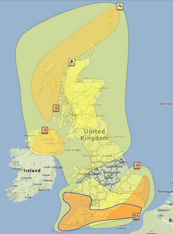
The image below shows weather warnings in force today across the UK...
December 24th - 00.01
It's Christmas Eve! 24 hours until Christmas, and for many it will be a very stormy 24 hours.
More travel disruption expected today as the winds move north. For information on train delays and cancellations, see the National Rail Enquiries website.
If you are due to catch a flight today, check with you airline for delays and flight cancellations.
For the next few hours the winds and rain will continue to affect the South of the country. As the storm moves north, the North of England and Scotland will experience strong gale force to storm force winds.
December 23rd - 23.52
Earlier, Channel 4 weather man Liam Dutton posted a picture of the storm as seen from space...
Beautiful but dangerous. A look at tonight's #ukstorm from space. That's one big swirl. pic.twitter.com/1fVkkIsEbe
— Liam Dutton - Weatherman (@liamdutton) December 23, 2013
December 23rd - 23.44
As winds continue to batter the south of England, it flooding caused by persistent rain that is causing the real problems.
The M23 is now closed both ways 10a-11 due to flooding.
Kerves lane in Horsham is now impassable.
A picture of flooding on the A22 near east Grinstead has been sent to us...
Another picture from Horsham of flooding at Gorringes Brook...
Tonbridge Wells has also seen flooding tonight...
Photo: GLITTERATI on the Pantiles almost got hit! #TunbridgeWells #Flood @Kent_999s pic.twitter.com/4rILYeqUJ9
— Jason Reeve Photography (@JasonReevePhoto) December 23, 2013
December 23rd - 20.31
We have now published information on weather warnings for tomorrow (Christmas Eve) see it here.
December 23rd - 19.41
Winds and rain are easing in the south east, but are expected to return in the early hours of Christmas Eve.
The storm has caused severe disruption to train, road and air travel, as well as flooding and disruptions to power supplies. The storm will affect the south east in the early hours of the morning and Scotland and the North of England tomorrow.
December 23rd - 17.59
Brittany Ferries has confirmed that a passenger on the Portsmouth to Bilbao crossing had to be airlifted off the ship after sustaining neck injuries during rough weather.
Flights from Southampton Airport have been temporarily suspended because of the high winds.
December 23rd - 17.20
A woman has died in the river Ogwen near Bethesda, Wales.
December 23rd - 17.20
The public are being urged to stay our of lakes and rivers after a body was pulled from the Rothay River at 3.30pm today. A Cumbria Fire spokesperson said the man had fallen into the part of the river near Ambleside Football Club.
December 23rd - 17.15
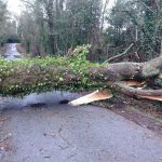
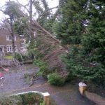
Many trees have fallen victim to today's storms, some blocking roads and train tracks others causing less disruption..
#HeartNews fallen tree in #Hitchin #Hertfordshire pic.twitter.com/Bf2buehAtC
— Amy Woodfield (@amy_woodfield) December 23, 2013
Gallery: motorists try their luck getting past a fallen tree between Yeovil and West Coker - http://t.co/uLJtRA4vd5 pic.twitter.com/L57DwOv8au
— Somerset Live (@SomersetLive) December 23, 2013
Fallen tree is covering half of the A3 (southbound, coming from New Malden to Chessington) @BBCLondonNews #UKStorm pic.twitter.com/cd9x1Y4DwY
— Sean Lawless (@SeanLawless90) December 23, 2013
Fallen tree between Lloyd park and sandilands pic.twitter.com/DD22ZVlvOc
— Matt Woosnam (@MattWoosie) December 23, 2013
December 23rd - 17.10
The Orwell bridge, Cambridgeshire has been closed.
Train services have been severely affected. Information on rail network service disruptions can be found on the National Rail Enquiries website.
December 23rd - 17.05
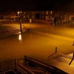
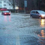
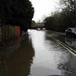
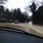
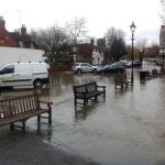
Flooding is becoming a serious problem in the south and the worst is yet to come. Persistent rain falling on already saturated ground is causing rivers to swell and surface water to form on roads.
@bbcweather #UKStorm pic.twitter.com/BCLSVoTAN3
— G (@gogrules) December 23, 2013
#flooding pic.twitter.com/bQWf5tTH70
— Emily (@Emjames3) December 23, 2013
The river Tavy approaching the top of Tavistock bridge arches in Devon @bbcweather #ukstorm pic.twitter.com/UbtfG9sfiY
— Strategic Cities (@StrategicCities) December 23, 2013
https://twitter.com/NicJaL/statuses/415165352579174400
December 23rd - 16.45
The worst of the winds still to come in the South East between 1am and 3am on Tuesday morning. 80mph gusts expected on the South East coast, and 60 - 70mph inland.
December 23rd - 16.15
Our Facebook page follower Susan Fernandez reports that the storm is now very bad in London.
Where we are based, in Horsham, West Sussex, the winds have really picked up in the last hour.
December 23rd - 15.15
The Environment Agency have again increased the number of flood warnings - where flooding is expected and immediate action required - to 16. There are also 154 flood alerts across the country. Check The Environment Agency website for flood information in your area.
December 23rd - 15.15
Emergency services have been called to North Street in Horsham after reports of a tree which has fallen and hit a child this afternoon (Monday December 23), say Horsham police.
December 23rd - 15.02
It may be very wet, but its an extremely tricky day for Brollies...
Meanwhile in Birmingham the brollie death toll continues to rise #ukstorm @bbcmtd pic.twitter.com/QaQDGN8YzT
— Giles Latcham (@GilesLatcham) December 23, 2013
A friend struggles with his umbrella in Hyde Park, London this afternoon #UKstorm pic.twitter.com/9n3lBRAAGr
— Jonathan (@jono1971) December 23, 2013
Winds and rain continue to hit the Dorset coast...
St Oswalds Bay, South Dorset. Gusts of winds nearing 70mph. New landslip too. #UKStorm #Dorset pic.twitter.com/wxsy217gLR
— James Gale (@James__Gale) December 23, 2013
December 23rd - 14.56
On of our Facebook page followers, Joanne Walker, sent a message saying that Stockport, Greater Manchester is now extremely windy and rainy.
ITV news reports that the River Cynon in the Rhondda valleys, south Wales, has burst its banks in Aberdare.
December 23rd - 14.12
The wind is starting to pick up in Essex...
https://twitter.com/JRWelham/statuses/415122354482995200
December 23rd - 14.10
The #A377 is blocked Exeter bound near Copplestone, Devon due to a fallen tree.
A new high wind speed for today's storm has been recorded at Capel Curig in Conwy, North Wales, with gusts blowing at 87mph.
December 23rd - 13.55
The number of homes and businesses without power in Cornwall has increased to 3,000
A picture of stormy sea's at Bracelet Bay, Swansea, posted on Twitter...
December 23rd - 13.55
A stormy Bracelet Bay today Swansea pic.twitter.com/EXCYxUfDI0
— Richie Hammond (@Richie_Hammond) December 23, 2013
The BBC post a picture of a fallen tree in Carmarthenshire...
UPDATE: Just in - photo of a fallen tree at Llangyndeyrn, Carmarthenshire from our camera crew http://t.co/OzdboCY5LL pic.twitter.com/qXyNenstdD
— BBC Wales News (@BBCWalesNews) December 23, 2013
December 23rd - 13.39
The Prime Minister Tweeted a few minutes ago..
My thoughts are with those affected by severe weather, particularly those without power. Govt depts and agencies doing all they can to help.
— David Cameron (@David_Cameron) December 23, 2013
December 23rd - 13.30
The port of Dover issue the following announcement...
In anticipation of the high winds (potentially with gusts of 60-70mph this evening and 70-80mph tonight) which are forecast for Monday 23rd December into Tuesday morning (Christmas Eve), the Port of Dover is advising its customers to contact their ferry operator and check the Port’s website (www.doverport.co.uk) or twitter account (@Port_of_Dover) for the latest information on Channel crossings.
The river Ebbw in Rogertone threaten to burst it's banks...
@UK_Crisis #UKStorm River Ebbw in #Rogerstone #Newport #Risca pic.twitter.com/dHj9mqJ9to
— Secret Coeliac (@RogerStoneWales) December 23, 2013
December 23rd - 13.25
The Met Office have added new Amber weather warnings of wind for Northern Ireland and Western Scotland tomorrow.
Winds and rain now affecting Cumbria...
https://twitter.com/CumbriaNews/statuses/415107085123080193
Eamont Bridge to Cliburn Road, Penrith is blocked due to flooding. Please avoid & find alternative route http://t.co/UVFvgLsbwM #ukstorm
— Cumbria Police (@Cumbriapolice) December 23, 2013
December 23rd - 13.15
There are now 122 food alerts and 8 flood warnings in England and Wales. For information on potential flooding in your area, visit the Environment Agency website.
Winds and rain are starting to intensify in the South East of England.
1,000 homes are without power in Plymouth according to Western Power Distribution.
Nearly 7,500 homes are without power in Berkshire. 7,000 homes are without power in the Bracknell area and 400 homes in Newbury.
The QEII Bridge in Dartford is now closed.
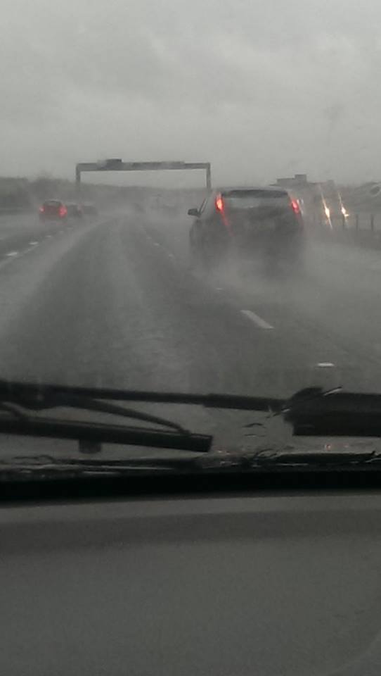
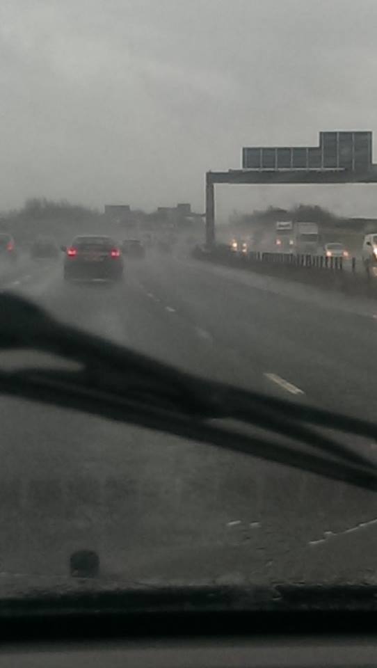
December 23rd - 12.40
Pictures sent to us of the hazardous driving conditions on the M1 motorway now...
December 23rd - 12.15
Messages from our Facebook followers...
Sara L Slater - On the M62 Northbound near Leeds. Speed restrictions of 40mph and tall lorries veering from side to side, scary!
Stephanie Minter - Dartford crossing (bridge) will closing at midday today until tomorrow. That means lakeside/ blue water shopping centres will be chaos. And don't even mention M25!
Becki Belgium - Cold very wet and windy Bristol
Anna Watkins - Hammering down with rain in a Burgess Hill, wind still not too bad but raining hard.
December 23rd - 11.45
The Met Office have extended yellow weather warnings of wind to include Essex, Suffolk, Norfolk and Lincolnshire.
The gale currently battering Cornwall is causing huge problems - the latest from 12 with @laurencereed @BBCKevinThomas & @BBCTravelSW
— BBC Radio Cornwall (@BBCCornwall) December 23, 2013
December 23rd - 11.24
Our Facebook follower, Susan Fernandez lets us know that the storm has not yet reached London. Susan is located in Woolwich London.
December 23rd - 11.15
The Met Office have issued a new Amber weather alert for wind in the South East of England early tomorrow morning...
Southwesterly gales and locally severe gales will continue across southern and eastern parts of England during Monday night, but are expected to strengthen further across parts of southeast England, in the Amber warning area, during the early hours of Tuesday, with gusts of 65-75 mph inland and 75-85 mph along exposed coasts. The winds will ease from the west by morning.
BBC Radio Cornwall Tweet...
Western Power Distribution says it's dealing with 60 weather related power cut incidents in Cornwall affecting 842 customers.
— BBC Radio Cornwall (@BBCCornwall) December 23, 2013
Our Facebook page follower, Angie Burton, posts "Raining and winds picking up in Portsmouth".
December 23rd - 10.59
The Cremyll Ferry To And From Admirals Hard In Plymouth Devon to Cremyll In Cornwall has cancelled services today.
December 23rd - 10.45
One of our Facebook followers, Andrea Banks, has sent us an update from Cornwall... "Trees down all over Cornwall, atrocious driving conditions, traffic is crazy."
Reports of Market Street in Hatherleigh, Devon being closed due to debris from roofs falling in road.
The QEII Bridge in Dartford, Kent will close shortly after midday due to weather warnings, Essex Police said that the bridge is expected to remain closed for 16 hours, reopening at about 04:00 BST tomorrow. The tunnel will remain open but severe congestion is expected so drivers are advised to take an alternative route.
December 23rd - 10.40
464 homes in Callington/St Dominick, Cornwall are without power.
The strongest gust recorded so far today is 74mph in St. Mary's on the Isles of Scilly.
December 23rd - 10.25
Reports of fallen tree in Devon. The A386 Parkwood Road the road is blocked due to fallen tree at turn for Kelly College.
Gatwick airport have the following announcement for passengers...
London Gatwick is currently operating as normal. Due to expected high winds later today, we are advising passengers to check with their airline before travelling and to leave additional time for their journey to the airport.
December 23rd - 10.05
Reports of fallen trees in Cornwall. The B3300 is partially blocked due to fallen tree between Tolticken Hill (Portreath) and Old Portreath Road.
Isles of Scilly Travel have said that all today's flights have been cancelled and rescheduled to tomorrow.
December 23rd - 09.20
Apparently it's raining fish in Tunbridge Wells, says one of our Facebook followers...
Mike Swann - It's literally raining fish in Tunbridge Wells, maybe a few hundred or a thousand, big silver ones.....it'll be on the bbc shortly, they have a news crew here.
360 homes are now without power on the Lizard peninsula in south Cornwall, because of a fault on the overhead power lines. Western Power Distribution says it's weather related.
December 23rd - 08.50
St Mawes Ferry, Cornwall, cancelled today due to forecast sea condition.
Messages from our Facebook followers
Andrea Banks - Really windy, picking up all the time, just had a huge gust (Truro, Cornwall)
Stephen Uwins - Ground is wet in Horsham, wind picking up a bit
Anna Watkins - Nothing to speak of yet. The ground is wet and it's a little windy but that's it so far (Burgess Hill).
Sara L Slater - Nothing here yet, Saddleworth Moor.
Please add your weather updates to our Facebook page, even if nothing is happening where you are yet.
December 23rd - 08.40
The wind has started to gradually pick up in the south west and along the south coast. We just Heard from St. Agnes in Cornwall, the wind and rain has begun.
Trains will be disrupted today, there will be a 50mph speed limit in force for a lot of journeys, causing severe delays and train cancellations. Many train companies are advising to travel early today and allowing passengers with a ticket valid for any time today to travel on an earlier train.
December 22nd - 23.55
The highways agency issued the following statement earlier tonight...
Currently, the Agency, in conjunction with the Met Office, is advising drivers of high-sided or other vehicles vulnerable to high winds, should avoid the following roads if possible during the weather alert:
East
A14 Orwell Bridge, near Ipswich – main risk period from 1300 Monday
A282 QE2 Bridge/Dartford Bridge – main risk period from 1200 MondaySouth East
Gusts of up to 70mph possible from 1200 Monday to 0400 Tuesday in the following locations:
M27 junction 8 to 9, Hedge Head to Locks Heath
A27 Shoreham Flyover, near to Hove/Brighton
A2 Jubilee Way close to Dover
M2 junction 2 to 3
A249 Kings Ferry/Sheppy Crossing
A282 QE2 Bridge/Dartford BridgeSouth West
A30/A38 Bodmin - gusts in excess of 60mph possible from 0900 to 1400 Monday
Gusts in excess of 60mph possible from 0900 to 1500 Monday in the following locations:
M4 junction 22 to 23, Severn Crossing
M48 junction1 to 2, Severn Crossing
M49, known as M4 junction 22 (at Severn Crossing) to M5 junction 18 (at Avonmouth)
M5 junction 18 to 19, Avonmouth Bridge
M5 junction 20 to 23, Clevedon to Bridgwater
December 22nd - 22.12
Allison Carter, one of our followers on Facebook has Alerted us to the fact that all Condor ferries from Weymouth Dorset have been cancelled for the morning and afternoon of Monday the 23rd. Ferries are being rescheduled, see the Condor ferries website for rescheduling information.
There is likely to be a 50mph speed restriction on train services tomorrow, which is likely to cause delays and cancellations. Information on rail network service disruptions can be found on the National Rail Enquiries website.
December 22nd - 19:40
It's becoming clear just how many people will be affected if there are travel disruptions tomorrow. More and more worried people posting their frustrations and asking for advice on twitter.
Will the #ukstorm mean I have to stay in tomorrow or are the train companies just trying to put off passengers on an already busy day?
— drellen (@nellefant) December 22, 2013
#UKStorm East Coast please advise- My fathers due to travel from Doncaster to London KX cmidday- He has 1st class ticket- travel earlier?
— Jonny Lefley (@jonlefley) December 22, 2013
I seem to only pick days to travel home on where severe weather will drastically affect my journey. #pants #ukstorm
— Kelly Li (@kwsli) December 22, 2013
Woman against weather, Christmas travellers and disrupted train travel back to Devon tomorrow. Wish me luck! #ukstorm
— LJ (@GeostuffJones) December 22, 2013
@FGW what is your policy on the #ukstorm 23rd dec ? I have a ticket for 13.45 to Wales tomorrow. Can I travel earlier tomorrow ??
— Julia Kasper (@Kaspertweet) December 22, 2013
Hang on - storm tomorrow? Will this affect flights? #ukstorm
— Paulus (@pickupapumpkin) December 22, 2013
December 22nd - 19:25
We're asking our Facebook followers to send us brief reports on the weather and any disruptions or damage in their area on Monday and Christmas eve. If you would like to be one of those who will send us an update every now and then through through the storm, please let us know on our Facebook page. We'll publish your reports on this page and on our Facebook page, and you will be helping people to get information on the strength and track of the storm.
December 22nd - 17:55
This graphic posted on Twitter earlier shows the low pressure system we are expecting.
MON & TUES #weatherbomb looking less than 936mb! That's lower than Hurricane Sandy which was a Cat 3 #ukstorm pic.twitter.com/djaiXP57Ph
— PAUL KINGSTON (@PaulKingstonITV) December 22, 2013
This is a very deep and rapidly developing low. When pressure within a weather system falls by 24 millibars in a 24 hour period is is referred to as a Weather Bomb, this coming low is expected to fall by 50 millibars within a 24 hour period.
December 22nd - 17:30
Many train services have lifted ticket restrictions allowing people to travel ahead of the storm. There is expected to be severe disruption the the rail networks tomorrow. Information on rail network service disruptions can be found on the National Rail Enquiries website.
The storm has the potential to cause major major disruptions to power supplies which could in some areas last into Monday evening.
The Environment agency has 71 flood alerts and 6 flood warnings in force. This number is expected to rise as Monday's rain falls on already saturated ground. Check for flood alerts and warnings in your area.
The storm is also expected to cause delays and cancellations at UK airports. Heathrow airport has the following warning on it's website this evening "High winds and heavy rain are forecast for Heathrow and much of the UK on Monday (Dec 23) afternoon. Passengers are advised to check the status of their flight with their airline prior to travelling to the airport as the weather may cause some schedule disruptions".